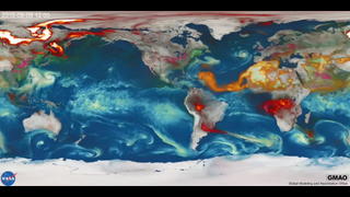
NASA animation shows global effects of Australia wildfires, hurricanes and more
The recent catastrophic bush fires in Australia were so immensely destructive that they could be seen from space. Now, a new animation from NASA shows the impact of those fires and other extreme disasters around the world from the past year.
In addition to the Australian fires, which began in 2019 and extended into January 2020, this animation shows the impacts of Hurricane Dorian, which took place from August to September 2019, and a series of major fires that took place in South America and Indonesia during the same period. Climate change, which researchers continue to study and monitor using space-based satellites, causes an increase in extreme weather events like those shown in the animation above.
Smoke from the Australian bush fires, which astronauts could see from aboard the International Space Station, has interacted with global weather. Smoke plumes have traveled around the globe, accelerating into the upper troposphere (the lowest region of Earth's atmosphere) and even as high up as the lowermost region of the stratosphere (the second layer of Earth's atmosphere, it sits above the troposphere and below the mesosphere).
Photos: Australia's deadly wildfires in photos: The view from space
Related: The reality of climate change: 10 myths busted

The long-range transport of the bushfire smoke will travel all the way across the Southern Ocean, completing a full circumnavigation of the planet to return to Australia. It is especially prominent across the southern Pacific Ocean and toward South America, according to a NASA statement.
While astronauts spotted the growing, billowing smoke from the Australian bush fires, satellites from NASA and the European Space Agency continue to monitor the effects of the fires. Data from these satellites have shown just how deadly the bush fires were to both the people and wildlife of Australia. Satellite imagery has provided evidence for where the fires spread.
The blazes have so far killed at least 25 people. Additionally, satellites have shown that the fires burned about one-third of Kangaroo Island, which is home to a variety of protected species. Devastation from the fires has also been spotted in a number of other areas where protected wildlife previously flourished.
- Astronauts Spot Australia's Deadly Wildfires from Space Station
- Satellite Images Show Australia's Devastating Wildfires from Space
- Devastation from Deadly Camp and Woolsey Fires Seen from Space
Follow Chelsea Gohd on Twitter @chelsea_gohd. Follow us on Twitter @Spacedotcom and on Facebook.
Get the Space.com Newsletter
Breaking space news, the latest updates on rocket launches, skywatching events and more!

Join our Space Forums to keep talking space on the latest missions, night sky and more! And if you have a news tip, correction or comment, let us know at: community@space.com.

Chelsea “Foxanne” Gohd joined Space.com in 2018 and is now a Senior Writer, writing about everything from climate change to planetary science and human spaceflight in both articles and on-camera in videos. With a degree in Public Health and biological sciences, Chelsea has written and worked for institutions including the American Museum of Natural History, Scientific American, Discover Magazine Blog, Astronomy Magazine and Live Science. When not writing, editing or filming something space-y, Chelsea "Foxanne" Gohd is writing music and performing as Foxanne, even launching a song to space in 2021 with Inspiration4. You can follow her on Twitter @chelsea_gohd and @foxannemusic.
