Typhoon Noru's Fury Seen from Space by Astronauts, Satellites
Three space fliers posted views of Super Typhoon Noru whirling across Earth Aug. 1, and satellites caught vivid images of the storm as well.
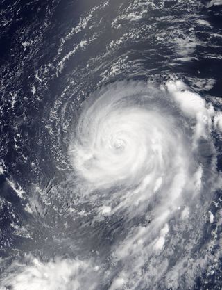
The typhoon clearly displays its power and might in these images taken by Astronaut Randy Bresnik from the International Space Station . The eye of the storm and its winding storm clouds leave a vivid impression.
NASA astronaut Jack Fischer tweeted another view of the storm:
And Russian cosmonaut Fyodor Yurchikhin, newly arrived to the station along with Bresnik, tweeted his own image of the swirling mass.
Yurchikhin and Bresnik have been on the station for just five days, although they'd both been in space before.

Seen from NASA's Terra satellite, bands of thunderstorms seem to envelop Noru's eye in a July 31 image by the Moderate Resolution Imaging Spectroradiometer (MODIS) instrument, circling the very large, defined core of the storm. [Hurricanes, Typhoons and Cyclones: Storms of Many Names]
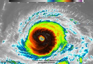
Noru's sustained winds were at 90 knots (103.6 mph), down from 125 knots (143.8 mph) on the morning of July 30. In an infrared light image by NASA-NOAA's Suomi NPP satellite on July 30, taken by the Visible Infrared Imaging Radiometer Suite (VIIRS) instrument, the cloud top of Noru reached temperatures as low as 190 Kelvin (-117.7 degrees Fahrenheit). Typically the frigid temperatures translate into very heavy rains produced by these storms.
Get the Space.com Newsletter
Breaking space news, the latest updates on rocket launches, skywatching events and more!

Noru was headed toward Japan's Iwo To Island at about 7 knots (8 mph). The storm is expected to make landfall on Kyushu, Japan's third largest and most southwest island, on Aug. 5. While the storm has weakened slightly, its intensity is expected to rise and fall as it approaches southwestern Japan.
Follow us @Spacedotcom, Facebook and Google+. Originally published on Space.com.
Join our Space Forums to keep talking space on the latest missions, night sky and more! And if you have a news tip, correction or comment, let us know at: community@space.com.

Christine Lunsford joined the Space.com team in 2010 as a freelance producer and later became a contributing writer, covering astrophotography images, astronomy photos and amazing space galleries and more. During her more than 10 years with Space.com, oversaw the site's monthly skywatching updates and produced overnight features and stories on the latest space discoveries. She enjoys learning about subjects of all kinds.
